


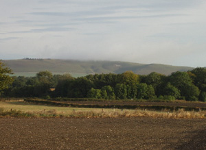
Vale landscape running West from Devizes bounded by the chalk escarpments of the Downs South of Marlborough to the North and Salisbury Plain to the South.
An important conglomeration of prehistoric sites which include extensive Mesolithic flint scatters at Free Warren Farm; numerous Neolithic flint scatters; the Neolithic Marden Henge and associated sites. Significant areas of 1700-1900 enclosure survive to the West of the area, combined with relict water meadow. These are an important historical survival representing evidence of land use in this period and of the Sheep-Corn system of agriculture. There is a varied and rich evidence base of architectural heritage dating to the Medieval period onwards.
North Wessex Downs AONB HLCA Extract 13
Present Day Historic Landscape Character
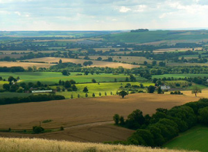
The present day character has a very mixed character forming a mosaic of unaltered pre 1700, and 1700 to 1900 fields surrounded by areas of 20th century enclosure. The survival of intact pre 1700 fieldscapes becomes denser in the East of the area. Some large blocks of 1700-1900 enclosure survive to the West of the area.
The area to the West and North of Pewsey is more wooded in character with regular post 1900 plantations and post 1600 to 1900 irregular deciduous woodlands being a much more noticeable component of the landscape than the areas to the East or West.
Small areas of open chalk downland survive on the tops of hill which form outcrops of the downland areas to the North.
The historic parklands preserve their historic characteristics.
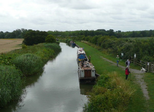
The most noticeable Post Medieval historic landscape component is the creation of an historic transportation corridor in the 19th century firstly by the canal and secondly by the railway, which both run East to West across the vale. The railway takes a central more direct route while the canal meanders to the North of the area. These are much more noticeable than the road network which maintains its pre 1800 pattern.
Layers in the Landscape
The density of recorded archaeology in this area is much less than in the downland areas to the North partly due to the more extensive exploitation of this area in the Post Medieval period obscuring archaeological traces and partly due to lack of exploitation in earlier periods.
Prehistoric archaeology was once presumed to be limited compared to the chalk downland areas to the North and South but new research has shown that it was exploited much more intensively than was previously thought. Important sites include extensive Mesolithic flint scatters at Free Warren Farm, numerous Neolithic flint scatters, Marden Henge and associated sites, and Hange to the North West of Wilsford House. There are several extant Bronze Age round barrows, plus ploughed out ring ditches. Dated later Bronze Age and Iron Age sites are infrequent though there is a density of undated field systems, many potentially prehistoric.
The western side of the area was dominated by a Medieval pattern of nucleated Medieval settlements surrounded by open fields which exploited the open grazing of downland areas to the South and North. These were enclosed pre 1700 at the same time as the aastern side. However the East of the area is defined by Medieval nucleated regular row settlements and does not have the same discernible pattern of open fields. Areas of pre 1700 irregular fields are concentrated between Bishop Cannings and Etchilhampton in the East of the area.
Large areas of parliamentary and post parliamentary enclosure were created across the West of the area enclosing areas of open fields which had not already been enclosed prior to 1750, the main area of parliamentary enclosure stretched from All Cannings to Marden with areas of post-parliamentary enclosure around Stanton St Bernard and Alton Barnes and South West of Coate. 1700 to 1900 enclosures are much less common to the East of the area due to the domination of pre 1700 enclosure. Water meadows were created along the River Avon and its tributaries but these were less dominating than in the narrow valley of the River Kennet to the North.
Designed pre 1700 to 1900 parkland was common to the centre and South West of the area including around the Manor House at Manningford Bruce, Wilcot Manor, Stowell Park, Rushall, Marden Manor and Conock Manor.
Historic Settlement Character
The historic settlement pattern is formed of nucleated settlements to the West surrounded by isolated historic farms. These agglomerated settlements are grouped around a single point, often a church or manor house. In contrast to the East of Pewsey pre 1700 linear regular row settlements predominate surrounded again by isolated historic farms. These have developed arranged contiguously along a road. The plots can be of regular width. There are some exceptions to this rule for example the irregular row settlement which is more dispersed in character which developed around Manningford Bruce and Manningford Abbot.
Historic Farmstead Character
The pattern of historic farms is of clusters of farms to the West away from villages these become smaller and more dispersed to the West. There is a low-medium concentration of pre-1750 farmstead buildings. These farmsteads are often large with loose courtyard plans or 19th century regular courtyard plans and are associated with the valley bottom. Large timber-frame barns, some of 15th century date but more often of 17th – 18th century date may be typical of many farms.